

The Wellington region will moved to Orange Level on Friday 3 December.
Read morePlease access our enquiry form below.
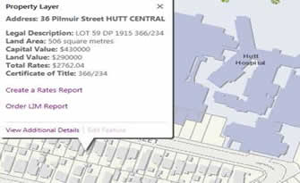
Bin Enquiry FormThe property, valuation and rates map also includes contours, water services and commonly required hazard zones.
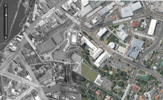
2017 high resolution ortho-rectified urban and rural aerial imagery
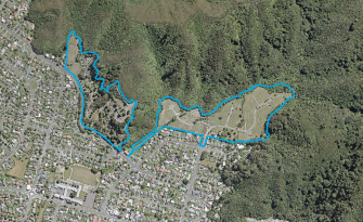
The Lower Hutt Cemeteries map shows locations for both council owned and private cemeteries. The blue boundary lines show the council owned cemeteries.
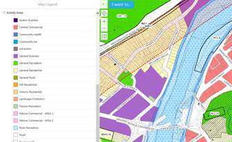
The District Plan activity areas map includes various other conditions which affect properties.
The historic aerial photography map has historic aerials of Lower Hutt from 1941 and 1969, through to 2017. Use the viewer to scroll through time.
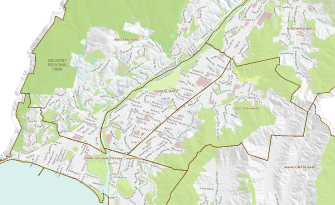
The interactive wards map shows the boundaries of Lower Hutt's 6 wards. Find what ward you're in by looking up your address.
View a map of car parks in Lower Hutt.
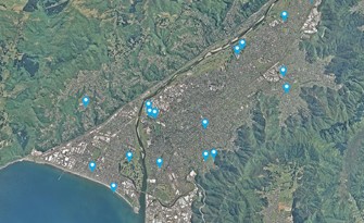
Find Public Toilets in Lower Hutt.
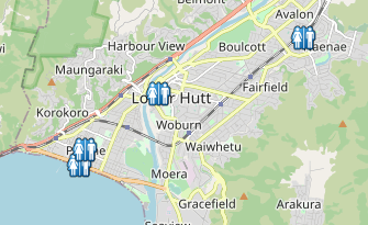
Find water fountains and taps in Lower Hutt.

 Alcohol licence appointment
Building inspection
Community dog training programme
Funding Advisor visit
Dog boarding
Dog safety programme
Eco Design Advisor
Food licence appointment
Gym membership
Metered parking space
Park, reserve, sportsground
Pool/spa safety inspection
Signboards
Swim membership
Venues
Alcohol licence appointment
Building inspection
Community dog training programme
Funding Advisor visit
Dog boarding
Dog safety programme
Eco Design Advisor
Food licence appointment
Gym membership
Metered parking space
Park, reserve, sportsground
Pool/spa safety inspection
Signboards
Swim membership
Venues
 Building consent application
Certificate of Acceptance
Certificate of Use
Compliance Schedule (BWoF)
Dog registration - new
Dog registration - renewal
Fines and infringements
Health registration renewal
Parking info/Pay My Park
Pool inspection fee
Rates
Resource consent application
Responsible dog owner status
Trade waste consent renewal
Building consent application
Certificate of Acceptance
Certificate of Use
Compliance Schedule (BWoF)
Dog registration - new
Dog registration - renewal
Fines and infringements
Health registration renewal
Parking info/Pay My Park
Pool inspection fee
Rates
Resource consent application
Responsible dog owner status
Trade waste consent renewal
 Annual plans
Annual reports
Archives online
Building consent fees
Building information / permits
BWoF
Bylaws
Cemeteries
City statistics
Compliance Schedules
Council meetings
District Licensing Decisions
District Plan online
Drainage plans
Elections 2019
Historic aerials
Libraries
Official Information Request
Research
Policies
Property information
Report a Problem tracker
Strategies
Annual plans
Annual reports
Archives online
Building consent fees
Building information / permits
BWoF
Bylaws
Cemeteries
City statistics
Compliance Schedules
Council meetings
District Licensing Decisions
District Plan online
Drainage plans
Elections 2019
Historic aerials
Libraries
Official Information Request
Research
Policies
Property information
Report a Problem tracker
Strategies


 Additional Dogs on Land or Premises
Amendment to Building consent application
Building consent application
Certificate of Acceptance application
Certificate for Public Use application
Certificate of Use application
Code Compliance Certificate application
Compliance Schedule Application
Dog registration - new
Dog registration refund
Food business registration
Funding applications
LIM
Outline Plan application
Replacement Dog Tags
Responsible dog owner status
Resource consent application
S. 223/224 RMA Certification application
Trade Waste discharge consent
Vehicle Crossing Construction
Additional Dogs on Land or Premises
Amendment to Building consent application
Building consent application
Certificate of Acceptance application
Certificate for Public Use application
Certificate of Use application
Code Compliance Certificate application
Compliance Schedule Application
Dog registration - new
Dog registration refund
Food business registration
Funding applications
LIM
Outline Plan application
Replacement Dog Tags
Responsible dog owner status
Resource consent application
S. 223/224 RMA Certification application
Trade Waste discharge consent
Vehicle Crossing Construction


