
The Wellington region will moved to Orange Level on Friday 3 December.
Read morePlease access our enquiry form below.
Bin Enquiry FormWellington Water has produced draft stormwater flood maps for urban Lower Hutt, and Greater Wellington Regional Council has developed draft river flood maps for the city.
We're taking maps of previous flood events and some new draft flood maps to communities across the city for residents to view, ask questions and learn more about how natural hazards can be managed through the district plan - Lower Hutt's rule book for land use and development.
We also need people to share their memories and photos of past flood events so we can use this information to make the final maps as accurate as possible.
The stormwater flood hazard maps can be found here.
Greater Wellington's river flood hazard maps can be accesssed from this page.
We're also keen to talk to you and hear your views on other natural hazards, like earthquakes and slips. For more information and to have your say, go here.
Maps and more information about a range of other natural hazards like earthquakes can be found here.
Come along to our public information sessions, view the maps, ask questions and bring your memories or photos of past flood events. They are on:
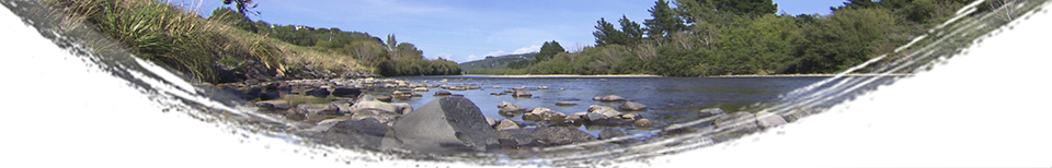
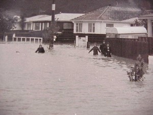
Lower Hutt is the most densely populated flood plain in New Zealand. The city has a history of flooding, and the projected effects of climate change makes flooding a complex and difficult natural hazard to manage.
To give us a clearer understanding of stormwater flood risks in Lower Hutt and better prepare for the future, Wellington Water (which manages water services for the Wellington Region’s councils) is modelling the likely impacts of extreme rainfall on the urban areas of Lower Hutt.
Computer modelling identifies areas that are affected by heavy rainfall draining from the hills into urban areas, from roofs, roads, footpaths and the water's overland paths to drains, streams and rivers. This information is converted into maps.
The computer modelling:
The resulting stormwater flood hazard maps depict flooding in 1 in 100 year and 1 in 10 year floods. They show:
The work represents the most comprehensive flood hazard mapping in the city’s history. It is expected to be completed by the end of 2021. The modelling of urban Wainuiomata is the first model to be completed. This is now being followed by Stokes Valley, Petone and Alicetown. In the coming months, the Waiwhetū catchment, which includes most of the Te Awa Kairangi/Hutt River valley floor, will be completed.
The maps will help reduce the impact of flooding by giving council, the community and government agencies a better understanding of future flood events. This means we can improve infrastructure, our urban planning and our responses during extreme rainfall events.
An important part of finalising the maps is asking local people about their experiences of flooding on their properties and in their neighbourhoods. Wellington Water and council staff will be showing draft maps to residents and seeking their observations and photos of past events at public drop-in sessions to ensure the maps are as accurate as possible.
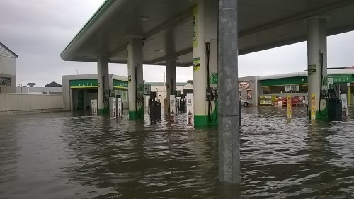
The main aim of this project is to protect life and property.
The information provided by the maps will be used in the review of the city's district plan, which includes the land use rules for Lower Hutt. This review is now underway. Council has a responsibility to ensure future developments avoid flood prone areas and do not make flooding risk worse for existing properties.
All councils are required to make natural hazard information public. Any property with a history of flooding, or identified as flood prone through this process, will have this information added to its Land Information Memorandum (LIM).
The flood hazard maps will provide crucial information for the forward planning of stormwater and other infrastructure in Lower Hutt. They will also be an important resource for local civil defence planning.
 The first modelling to be completed is of urban Wainuiomata. To ensure the maps are as accurate as possible, Wellington Water and Hutt City Council held two public drop-in sessions.
This enabled residents to view the maps, ask questions about the project and provide their observations and photos of past flooding events. This information was used to fine tune the maps, which are now finalised.
A similar rocess is now underway for the rest of urban Lower Hutt. Please see venues and dates at the top of this page.
For more information on the flood hazard mapping project, see the frequently asked questions or contact Wellington Water at: floodmap@wellingtonwater.co.nz

 Alcohol licence appointment
Building inspection
Community dog training programme
Funding Advisor visit
Dog boarding
Dog safety programme
Eco Design Advisor
Food licence appointment
Gym membership
Metered parking space
Park, reserve, sportsground
Pool/spa safety inspection
Signboards
Swim membership
Venues
Alcohol licence appointment
Building inspection
Community dog training programme
Funding Advisor visit
Dog boarding
Dog safety programme
Eco Design Advisor
Food licence appointment
Gym membership
Metered parking space
Park, reserve, sportsground
Pool/spa safety inspection
Signboards
Swim membership
Venues
 Building consent application
Certificate of Acceptance
Certificate of Use
Compliance Schedule (BWoF)
Dog registration - new
Dog registration - renewal
Fines and infringements
Health registration renewal
Parking info/Pay My Park
Pool inspection fee
Rates
Resource consent application
Responsible dog owner status
Trade waste consent renewal
Building consent application
Certificate of Acceptance
Certificate of Use
Compliance Schedule (BWoF)
Dog registration - new
Dog registration - renewal
Fines and infringements
Health registration renewal
Parking info/Pay My Park
Pool inspection fee
Rates
Resource consent application
Responsible dog owner status
Trade waste consent renewal
 Annual plans
Annual reports
Archives online
Building consent fees
Building information / permits
BWoF
Bylaws
Cemeteries
City statistics
Compliance Schedules
Council meetings
District Licensing Decisions
District Plan online
Drainage plans
Elections 2019
Historic aerials
Libraries
Official Information Request
Research
Policies
Property information
Report a Problem tracker
Strategies
Annual plans
Annual reports
Archives online
Building consent fees
Building information / permits
BWoF
Bylaws
Cemeteries
City statistics
Compliance Schedules
Council meetings
District Licensing Decisions
District Plan online
Drainage plans
Elections 2019
Historic aerials
Libraries
Official Information Request
Research
Policies
Property information
Report a Problem tracker
Strategies


 Additional Dogs on Land or Premises
Amendment to Building consent application
Building consent application
Certificate of Acceptance application
Certificate for Public Use application
Certificate of Use application
Code Compliance Certificate application
Compliance Schedule Application
Dog registration - new
Dog registration refund
Food business registration
Funding applications
LIM
Outline Plan application
Replacement Dog Tags
Responsible dog owner status
Resource consent application
S. 223/224 RMA Certification application
Trade Waste discharge consent
Vehicle Crossing Construction
Additional Dogs on Land or Premises
Amendment to Building consent application
Building consent application
Certificate of Acceptance application
Certificate for Public Use application
Certificate of Use application
Code Compliance Certificate application
Compliance Schedule Application
Dog registration - new
Dog registration refund
Food business registration
Funding applications
LIM
Outline Plan application
Replacement Dog Tags
Responsible dog owner status
Resource consent application
S. 223/224 RMA Certification application
Trade Waste discharge consent
Vehicle Crossing Construction


